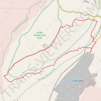
חיתוך בתוך המכתש הגדול, מנחל חתירה לסנפיר
- Distance: 20.6 mi
- Elevation gain: 3,625 ft
- Maximum elevation: 2,234 ft
- Elevation loss: 3,625 ft
- Minimum elevation: 997 ft
- Moving time: 7 h 48 m
- Moving speed: 2.6 mph
- Maximum speed: 8.1 mph
- Total time: 9 h 26 m
- Global speed: 2.2 mph
Interactive trail map
Trail profile
About this trail
Name: חיתוך בתוך המכתש הגדול, מנחל חתירה לסנפיר trail, distance, elevation, map, profile, GPS track
Start: 206, Ramat Negev Regional Council, Beersheba Subdistrict, South District, Israel (30.91531 35.01819)
End: 206, Ramat Negev Regional Council, Beersheba Subdistrict, South District, Israel (30.91478 35.01800)
Coordinates: 30.88595 34.91869 30.94871 35.02655
Other hiking, mountain biking, running and outdoor activity trails
Click on a trail to view its statistics, map and profile.
קישור בין נחל זקוף לנחל דרוך
Israel > South District > Ramat Negev Regional Council > Merchav Am
Distance: 23.6 mi • Elevation gain: 2,753 ft • Maximum elevation: 2,215 ft