Import a GPX file

Joe Batt's Arm-Barr'd Islands-Shoal Bay trails

Click on a trail to view its statistics, map and profile.
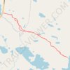
Cook's Pond Trail

Canada > Newfoundland and Labrador > Fogo Island > Joe Batt's Arm-Barr'd Islands-Shoal Bay

Distance: 3.4 mi • Elevation gain: 249 ft • Maximum elevation: 171 ft

Gear up for your next adventure:

⌚Solar GPS Watches - Advanced multisport watches with built-in topographic maps
🏔️Mountain Trail Maps - High‑detail maps for popular peaks
🛠️Outdoor Gear Repair Kit - Essential tools to fix gear on the trail
🛰️Satellite Messengers - Emergency SOS and two-way messaging for off-grid adventures
📦Gear Storage Bags - Organize and protect outdoor equipment

As an Amazon Associate, this site earns from qualifying purchases at no extra cost to you.