
Deer Mountain Trail in Rocky Mountain National Park trails
Click on a trail to view its statistics, map and profile.
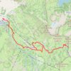
Catherine's Pass Trail via Upper Albion Meadows Trail and East Greeley Road
United States > Utah > Salt Lake County > Alta
The Catherine's Pass Trail is a scenic hike located in the Uinta-Wasatch-Cache National Forest near Alta, Utah. The route offers a captivating mix of alpine meadows, striking wildflower displays in spring, and expansive views of surrounding peaks like Mount Wolverine and Sunset Peak. Along the way, you can…
Distance: 5.6 mi • Elevation gain: 1,578 ft • Maximum elevation: 10,223 ft

Deer Mountain Trail in Rocky Mountain National Park
United States > Colorado > Larimer County
The Deer Mountain Trail in Rocky Mountain National Park offers hikers a moderately challenging ascent through serene ponderosa pine forests, leading to panoramic summit views. Along the trail, you'll encounter vistas of Little Horseshoe Park and the Mummy Range, with occasional sightings of local wildlife like…
Distance: 6.1 mi • Elevation gain: 1,411 ft • Maximum elevation: 9,967 ft