Catherine's Pass Trail via Upper Albion Meadows Trail and East Greeley Road
The Catherine's Pass Trail is a scenic hike located in the Uinta-Wasatch-Cache National Forest near Alta, Utah. The route offers a captivating mix of alpine meadows, striking wildflower displays in spring, and expansive views of surrounding peaks like Mount Wolverine and Sunset Peak. Along the way, you can enjoy the presence of local wildlife, including mule deer and moose, while navigating a terrain that ranges from moderate climbs to rocky stretches. This hike culminates at Catherine's Pass, where you'll be rewarded with sweeping vistas of nearby lakes and the surrounding mountain landscape. #Hiking #Mountain #Forest #Nature
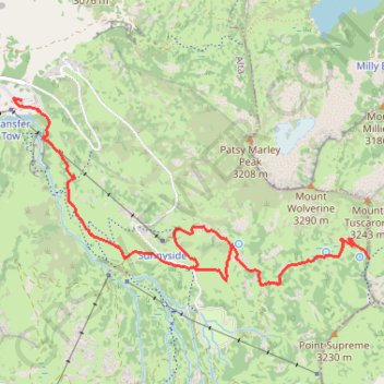
- Distance: 5.6 mi
- Elevation gain: 1,578 ft
- Maximum elevation: 10,223 ft
- Elevation loss: 1,591 ft
- Minimum elevation: 8,688 ft
Interactive trail map
Trail profile
- Distance: 5.6 mi
- Elevation gain: 1,578 ft
- Maximum elevation: 10,223 ft
- Elevation loss: 1,591 ft
- Minimum elevation: 8,688 ft
About this trail
Name: Catherine's Pass Trail via Upper Albion Meadows Trail and East Greeley Road trail, distance, elevation, map, profile, GPS track
Coordinates: 40.57901 -111.62859 40.59103 -111.59862
Topography: Salt Lake County topographic map, elevation, terrain
Other hiking, mountain biking, running and outdoor activity trails
Click on a trail to view its statistics, map and profile.
Cecret Lake Trail via Upper Albion Meadows Trail in Uinta-Wasatch-Cache National Forest
United States > Utah > Salt Lake County > Alta
The hike to Cecret Lake via the Upper Albion Meadows Trail offers a peaceful journey through colorful wildflower meadows, leading to a serene alpine lake surrounded by striking rocky cliffs. As you ascend, you’ll be treated to views of Albion Basin, where vibrant summer wildflowers and the chance to spot…
Distance: 4.6 mi • Elevation gain: 1,194 ft • Maximum elevation: 9,875 ft
Lake Mary Dam via Catherine's Pass Trail
United States > Utah > Salt Lake County > Alta
The Lake Mary Dam hike via Catherine’s Pass Trail offers a scenic and rewarding journey through the Uinta-Wasatch-Cache National Forest. Along the way, you'll encounter picturesque alpine lakes such as Lake Mary, Lake Martha, and Lake Catherine, with stunning views of rugged peaks like Mount Millicent. The…
Distance: 6.2 mi • Elevation gain: 1,765 ft • Maximum elevation: 10,223 ft