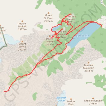
Lake Louise - Plain of the Six Glaciers
Interactive trail map
Trail profile
- Distance: 13.6 mi
- Elevation gain: 4,140 ft
- Maximum elevation: 7,661 ft
- Elevation loss: 4,134 ft
- Minimum elevation: 5,702 ft
About this trail
Name: Lake Louise - Plain of the Six Glaciers trail, distance, elevation, map, profile, GPS track
Start: Lac Louise, Improvement District No. 9, Alberta, Canada (51.41542 -116.21512)
End: Lac Louise, Improvement District No. 9, Alberta, Canada (51.41531 -116.21504)
Coordinates: 51.38637 -116.28513 51.42112 -116.21501
Other hiking, mountain biking, running and outdoor activity trails
Click on a trail to view its statistics, map and profile.
Lake Louise and Lake Agnes Loop
Canada > Alberta > Improvement District No. 9
Distance: 7.0 mi • Elevation gain: 2,195 ft • Maximum elevation: 7,395 ft