Thank you for supporting this site ❤️
Make a donation
Make a donation
Gear up for your next adventure:
As an Amazon Associate, this site earns from qualifying purchases at no extra cost to you.
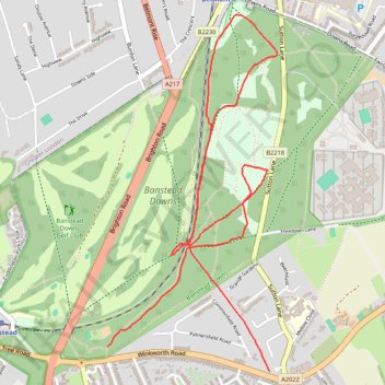
Run along paths in Banstead Common
- Distance: 3.4 mi
- Elevation gain: 246 ft
- Maximum elevation: 492 ft
- Elevation loss: 184 ft
- Minimum elevation: 312 ft
- Moving time: 38 m 38 s
- Moving speed: 5.3 mph
- Maximum speed: 10.7 mph
- Total time: 38 m 38 s
- Global speed: 5.3 mph
Interactive trail map
Thank you for supporting this site ❤️
Make a donation
Make a donation
Gear up for your next adventure:
As an Amazon Associate, this site earns from qualifying purchases at no extra cost to you.
Trail profile
- Distance: 3.4 mi
- Elevation gain: 246 ft
- Maximum elevation: 492 ft
- Elevation loss: 184 ft
- Minimum elevation: 312 ft
- Moving time: 38 m 38 s
- Moving speed: 5.3 mph
- Maximum speed: 10.7 mph
- Total time: 38 m 38 s
- Global speed: 5.3 mph
Thank you for supporting this site ❤️
Make a donation
Make a donation
Gear up for your next adventure:
As an Amazon Associate, this site earns from qualifying purchases at no extra cost to you.
About this trail
Name: Run along paths in Banstead Common trail, distance, elevation, map, profile, GPS track
Coordinates: 51.32736 -0.20628 51.34284 -0.19449
Thank you for supporting this site ❤️
Make a donation
Make a donation
Gear up for your next adventure:
As an Amazon Associate, this site earns from qualifying purchases at no extra cost to you.