Make a donation
Gear up for your next adventure:
As an Amazon Associate, this site earns from qualifying purchases at no extra cost to you.
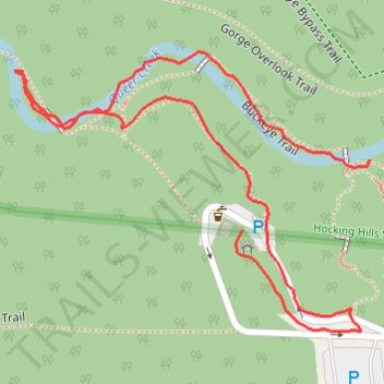
GoMap__2026_04_11__15_37_06
- Distance: 0.7 mi
- Elevation gain: 56 ft
- Maximum elevation: 889 ft
- Elevation loss: 85 ft
- Minimum elevation: 837 ft
- Moving time: 17 m 30 s
- Moving speed: 2.2 mph
- Maximum speed: 4.3 mph
- Total time: 18 m 56 s
- Global speed: 2.1 mph
Interactive trail map
Make a donation
Gear up for your next adventure:
As an Amazon Associate, this site earns from qualifying purchases at no extra cost to you.
Trail profile
- Distance: 0.7 mi
- Elevation gain: 56 ft
- Maximum elevation: 889 ft
- Elevation loss: 85 ft
- Minimum elevation: 837 ft
- Moving time: 17 m 30 s
- Moving speed: 2.2 mph
- Maximum speed: 4.3 mph
- Total time: 18 m 56 s
- Global speed: 2.1 mph
Make a donation
Gear up for your next adventure:
As an Amazon Associate, this site earns from qualifying purchases at no extra cost to you.
About this trail
Name: GoMap__2026_04_11__15_37_06 trail, distance, elevation, map, profile, GPS track
Start: Buckeye Trail, Benton Township, Hocking County, Ohio, United States (39.41816 -82.52647)
End: Gorge Overlook Trail, Benton Township, Hocking County, Ohio, United States (39.41870 -82.52522)
Coordinates: 39.41739 -82.52873 39.41953 -82.52522
Topography: Hocking County topographic map, elevation, terrain
Make a donation
Gear up for your next adventure:
As an Amazon Associate, this site earns from qualifying purchases at no extra cost to you.
Other hiking, mountain biking, running and outdoor activity trails
Click on a trail to view its statistics, map and profile.
Gorge Overlook Trail and Buckeye Trail Loop via Old Man's Cave, Whispering Falls, Cedar Falls and Rose Lake
United States > Ohio > Hocking County > Cedar Grove
The Gorge Overlook Trail and Buckeye Trail Loop, starting from Old Man's Cave, offers a scenic journey through Hocking Hills State Park, showcasing its diverse geological features and lush landscapes. Hikers will encounter impressive sandstone cliffs, picturesque waterfalls such as Cedar Falls and Whispering…
Distance: 5.9 mi • Elevation gain: 548 ft • Maximum elevation: 948 ft
Gorge Overlook Trail and Buckeye Trail Loop Hike in Hocking Hills State Park
United States > Ohio > Hocking County > Cedar Grove
The Gorge Overlook Trail and Buckeye Trail Loop in Hocking Hills State Park provide a captivating mix of geological wonders and natural beauty. Hikers will experience stunning sandstone cliffs, cascading waterfalls like Cedar Falls and Whispering Falls, and serene spots like Rose Lake and the lush, forested…
Distance: 5.5 mi • Elevation gain: 515 ft • Maximum elevation: 945 ft
Cedar Falls from Old Man's Cave via Buckeye Trail in Hocking Hills State Park
United States > Ohio > Hocking County > Cedar Grove
The hike from Old Man's Cave to Cedar Falls offers a blend of stunning natural beauty and unique geological features. As you traverse the trail, you'll encounter the towering hemlocks, steep sandstone cliffs, and cascading waters of Cedar Falls, which is particularly impressive after rainfall. The…
Distance: 5.4 mi • Elevation gain: 463 ft • Maximum elevation: 912 ft
Hocking Hills Cedar Falls Trail
United States > Ohio > Hocking County
Distance: 0.6 mi • Elevation gain: 43 ft • Maximum elevation: 883 ft
Make a donation
Gear up for your next adventure:
As an Amazon Associate, this site earns from qualifying purchases at no extra cost to you.
GoMap__2026_04_11__15_02_41
United States > Ohio > Hocking County
Distance: 1.3 mi • Elevation gain: 16 ft • Maximum elevation: 1,079 ft
GoMap__2026_04_11__16_27_02
United States > Ohio > Hocking County
Distance: 1.2 mi • Elevation gain: 203 ft • Maximum elevation: 1,076 ft