Thank you for supporting this site ❤️
Make a donation
Make a donation
Gear up for your next adventure:
As an Amazon Associate, this site earns from qualifying purchases at no extra cost to you.
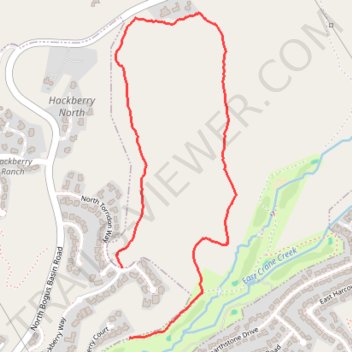
In the hills north of Boise
- Distance: 2.0 mi
- Elevation gain: 272 ft
- Maximum elevation: 3,379 ft
- Elevation loss: 446 ft
- Minimum elevation: 2,976 ft
- Moving time: 57 m 2 s
- Moving speed: 2.1 mph
- Maximum speed: 4.3 mph
- Total time: 57 m 2 s
- Global speed: 2.1 mph
Interactive trail map
Thank you for supporting this site ❤️
Make a donation
Make a donation
Gear up for your next adventure:
As an Amazon Associate, this site earns from qualifying purchases at no extra cost to you.
Trail profile
- Distance: 2.0 mi
- Elevation gain: 272 ft
- Maximum elevation: 3,379 ft
- Elevation loss: 446 ft
- Minimum elevation: 2,976 ft
- Moving time: 57 m 2 s
- Moving speed: 2.1 mph
- Maximum speed: 4.3 mph
- Total time: 57 m 2 s
- Global speed: 2.1 mph
Thank you for supporting this site ❤️
Make a donation
Make a donation
Gear up for your next adventure:
As an Amazon Associate, this site earns from qualifying purchases at no extra cost to you.
About this trail
Name: In the hills north of Boise trail, distance, elevation, map, profile, GPS track
Start: North Torridon Way, Highlands, Boise, Ada County, Idaho, 83702, United States (43.65640 -116.18643)
Coordinates: 43.65384 -116.18671 43.66567 -116.18068
Topography: Boise topographic map, elevation, terrain
Thank you for supporting this site ❤️
Make a donation
Make a donation
Gear up for your next adventure:
As an Amazon Associate, this site earns from qualifying purchases at no extra cost to you.