Make a donation
Gear up for your next adventure:
As an Amazon Associate, this site earns from qualifying purchases at no extra cost to you.
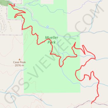
Rudys Flat
Mountain Bike to Rudys Flat via Mueller Park and Big Rock in Uinta-Wasatch-Cache National Forest. #MTB #Forest #Mountain #Nature
- Distance: 5.9 mi
- Elevation gain: 2,316 ft
- Maximum elevation: 7,182 ft
- Elevation loss: 407 ft
- Minimum elevation: 5,253 ft
- Moving time: 1 h 44 m
- Moving speed: 3.4 mph
- Maximum speed: 11.4 mph
- Total time: 2 h 21 m
- Global speed: 2.5 mph
Interactive trail map
Make a donation
Gear up for your next adventure:
As an Amazon Associate, this site earns from qualifying purchases at no extra cost to you.
Trail profile
- Distance: 5.9 mi
- Elevation gain: 2,316 ft
- Maximum elevation: 7,182 ft
- Elevation loss: 407 ft
- Minimum elevation: 5,253 ft
- Moving time: 1 h 44 m
- Moving speed: 3.4 mph
- Maximum speed: 11.4 mph
- Total time: 2 h 21 m
- Global speed: 2.5 mph
Make a donation
Gear up for your next adventure:
As an Amazon Associate, this site earns from qualifying purchases at no extra cost to you.
About this trail
Name: Rudys Flat trail, distance, elevation, map, profile, GPS track
Start: Mueller Park Road, Bountiful, Davis County, Utah, 84010, United States (40.86385 -111.83674)
End: Mueller Park Trail, Salt Lake City, Salt Lake County, Utah, United States (40.83933 -111.81169)
Coordinates: 40.83933 -111.83846 40.86386 -111.80927
Topography: Davis County topographic map, elevation, terrain
Make a donation
Gear up for your next adventure:
As an Amazon Associate, this site earns from qualifying purchases at no extra cost to you.
Other hiking, mountain biking, running and outdoor activity trails
Click on a trail to view its statistics, map and profile.
Canyon Creek Hike
United States > Utah > Davis County > Bountiful
Distance: 4.5 mi • Elevation gain: 1,063 ft • Maximum elevation: 6,522 ft