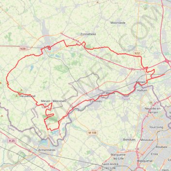
Gent-Wevelgem Cyclo 2022 - 90km
- Distance: 58.4 mi
- Elevation gain: 1,591 ft
- Maximum elevation: 495 ft
- Elevation loss: 1,591 ft
- Minimum elevation: 30 ft
Interactive trail map
Trail profile
- Distance: 58.4 mi
- Elevation gain: 1,591 ft
- Maximum elevation: 495 ft
- Elevation loss: 1,591 ft
- Minimum elevation: 30 ft
About this trail
Name: Gent-Wevelgem Cyclo 2022 - 90km trail, distance, elevation, map, profile, GPS track
End: 21, Vanackerestraat, Wevelgem, Kortrijk, West Flanders, Flanders, 8560, Belgium (50.80855 3.18201)
Coordinates: 50.71723 2.77927 50.86321 3.18214
Other hiking, mountain biking, running and outdoor activity trails
Click on a trail to view its statistics, map and profile.
Stadswandelroute_ieper
Belgium > West Flanders > Ieper > Ypres
Distance: 4.1 mi • Elevation gain: 69 ft • Maximum elevation: 85 ft
Donderdag 29 mei 2025 - 20 km
Belgium > West Flanders > Ieper > Ypres
<p>Van Leopold III-laan 16, 8900 Ieper, België<br/> Naar Leopold III-laan 16, 8900 Ieper, België</p> <p>Routering Wandel - mooiste, Manueel</p>
Distance: 12.5 mi • Elevation gain: 230 ft • Maximum elevation: 98 ft