Thank you for supporting this site ❤️
Make a donation
Make a donation
Gear up for your next adventure:
As an Amazon Associate, this site earns from qualifying purchases at no extra cost to you.
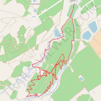
Boschendal Ride
- Distance: 10.6 mi
- Elevation gain: 1,532 ft
- Maximum elevation: 1,309 ft
- Elevation loss: 1,532 ft
- Minimum elevation: 558 ft
- Moving time: 1 h 34 m
- Moving speed: 6.8 mph
- Maximum speed: 28.6 mph
- Total time: 2 h 26 m
- Global speed: 4.3 mph
Interactive trail map
Thank you for supporting this site ❤️
Make a donation
Make a donation
Gear up for your next adventure:
As an Amazon Associate, this site earns from qualifying purchases at no extra cost to you.
Trail profile
- Distance: 10.6 mi
- Elevation gain: 1,532 ft
- Maximum elevation: 1,309 ft
- Elevation loss: 1,532 ft
- Minimum elevation: 558 ft
- Moving time: 1 h 34 m
- Moving speed: 6.8 mph
- Maximum speed: 28.6 mph
- Total time: 2 h 26 m
- Global speed: 4.3 mph
Thank you for supporting this site ❤️
Make a donation
Make a donation
Gear up for your next adventure:
As an Amazon Associate, this site earns from qualifying purchases at no extra cost to you.
About this trail
Name: Boschendal Ride trail, distance, elevation, map, profile, GPS track
Coordinates: -33.86918 18.93221 -33.84758 18.94566
Thank you for supporting this site ❤️
Make a donation
Make a donation
Gear up for your next adventure:
As an Amazon Associate, this site earns from qualifying purchases at no extra cost to you.
Other hiking, mountain biking, running and outdoor activity trails
Click on a trail to view its statistics, map and profile.
Boschendal MTB Black Route
South Africa > Western Cape > Cape Winelands District Municipality > Drakenstein Local Municipality
Distance: 14.3 mi • Elevation gain: 2,490 ft • Maximum elevation: 1,673 ft