Thank you for supporting this site ❤️
Make a donation
Make a donation
Gear up for your next adventure:
As an Amazon Associate, this site earns from qualifying purchases at no extra cost to you.
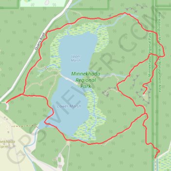
Minnekhada High Knoll Loop
Minnekhada Regional Park. #Hiking #Loop #Minnekhada
- Distance: 4.3 mi
- Elevation gain: 955 ft
- Maximum elevation: 518 ft
- Elevation loss: 955 ft
- Minimum elevation: 20 ft
Interactive trail map
Thank you for supporting this site ❤️
Make a donation
Make a donation
Gear up for your next adventure:
As an Amazon Associate, this site earns from qualifying purchases at no extra cost to you.
Trail profile
- Distance: 4.3 mi
- Elevation gain: 955 ft
- Maximum elevation: 518 ft
- Elevation loss: 955 ft
- Minimum elevation: 20 ft
Thank you for supporting this site ❤️
Make a donation
Make a donation
Gear up for your next adventure:
As an Amazon Associate, this site earns from qualifying purchases at no extra cost to you.
About this trail
Name: Minnekhada High Knoll Loop trail, distance, elevation, map, profile, GPS track
Coordinates: 49.29560 -122.70733 49.30717 -122.68797
Thank you for supporting this site ❤️
Make a donation
Make a donation
Gear up for your next adventure:
As an Amazon Associate, this site earns from qualifying purchases at no extra cost to you.
Other hiking, mountain biking, running and outdoor activity trails
Click on a trail to view its statistics, map and profile.