Make a donation
Gear up for your next adventure:
As an Amazon Associate, this site earns from qualifying purchases at no extra cost to you.
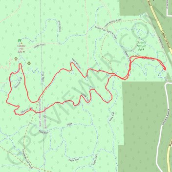
Cobble Hill Mountain Regional Recreation Area
#Hiking #Loop #CobbleHill
- Distance: 2.2 mi
- Elevation gain: 732 ft
- Maximum elevation: 1,030 ft
- Elevation loss: 732 ft
- Minimum elevation: 331 ft
Interactive trail map
Make a donation
Gear up for your next adventure:
As an Amazon Associate, this site earns from qualifying purchases at no extra cost to you.
Trail profile
- Distance: 2.2 mi
- Elevation gain: 732 ft
- Maximum elevation: 1,030 ft
- Elevation loss: 732 ft
- Minimum elevation: 331 ft
Make a donation
Gear up for your next adventure:
As an Amazon Associate, this site earns from qualifying purchases at no extra cost to you.
About this trail
Name: Cobble Hill Mountain Regional Recreation Area trail, distance, elevation, map, profile, GPS track
Coordinates: 48.68452 -123.61895 48.68785 -123.60524
Make a donation
Gear up for your next adventure:
As an Amazon Associate, this site earns from qualifying purchases at no extra cost to you.
Other hiking, mountain biking, running and outdoor activity trails
Click on a trail to view its statistics, map and profile.
Cobble Hill Loop
Canada > British Columbia > Cowichan Valley Regional District > Area C (Cobble Hill) > Cobble Hill
Cobble Hill Mountain Regional Recreation Area. #Hiking #MTB #Loop #CobbleHill
Distance: 4.5 mi • Elevation gain: 1,066 ft • Maximum elevation: 1,050 ft
BBF loop to the Skydeck in Nanaimo
Canada > British Columbia > Cowichan Valley Regional District > Area A (Mill Bay / Malahat) > Mill Bay
BBF loop to the Skydeck
Distance: 201.0 mi • Elevation gain: 20,413 ft • Maximum elevation: 2,316 ft