Thank you for supporting this site ❤️
Make a donation
Make a donation
Gear up for your next adventure:
As an Amazon Associate, this site earns from qualifying purchases at no extra cost to you.
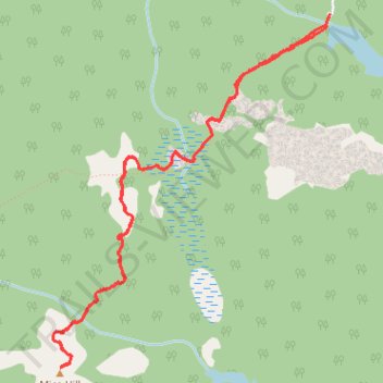
Mica Hill Hiking Trail from Paquets Lake
- Distance: 4.9 mi
- Elevation gain: 571 ft
- Maximum elevation: 1,329 ft
- Elevation loss: 568 ft
- Minimum elevation: 866 ft
- Moving time: 1 h 59 m
- Moving speed: 2.5 mph
- Maximum speed: 3.8 mph
- Total time: 2 h 37 m
- Global speed: 1.9 mph
Interactive trail map
Thank you for supporting this site ❤️
Make a donation
Make a donation
Gear up for your next adventure:
As an Amazon Associate, this site earns from qualifying purchases at no extra cost to you.
Trail profile
- Distance: 4.9 mi
- Elevation gain: 571 ft
- Maximum elevation: 1,329 ft
- Elevation loss: 568 ft
- Minimum elevation: 866 ft
- Moving time: 1 h 59 m
- Moving speed: 2.5 mph
- Maximum speed: 3.8 mph
- Total time: 2 h 37 m
- Global speed: 1.9 mph
Thank you for supporting this site ❤️
Make a donation
Make a donation
Gear up for your next adventure:
As an Amazon Associate, this site earns from qualifying purchases at no extra cost to you.
About this trail
Name: Mica Hill Hiking Trail from Paquets Lake trail, distance, elevation, map, profile, GPS track
Coordinates: 46.81478 -60.45712 46.83491 -60.43407
Thank you for supporting this site ❤️
Make a donation
Make a donation
Gear up for your next adventure:
As an Amazon Associate, this site earns from qualifying purchases at no extra cost to you.