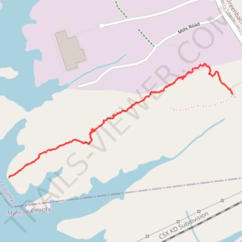
Tellico Reservoir - East Lakeshore trail
- Distance: 1.3 mi
- Elevation gain: 167 ft
- Maximum elevation: 1,010 ft
- Elevation loss: 194 ft
- Minimum elevation: 833 ft
- Moving time: 30 m 1 s
- Moving speed: 2.7 mph
- Maximum speed: 5.4 mph
- Total time: 32 m 10 s
- Global speed: 2.5 mph
Interactive trail map
Trail profile
- Distance: 1.3 mi
- Elevation gain: 167 ft
- Maximum elevation: 1,010 ft
- Elevation loss: 194 ft
- Minimum elevation: 833 ft
- Moving time: 30 m 1 s
- Moving speed: 2.7 mph
- Maximum speed: 5.4 mph
- Total time: 32 m 10 s
- Global speed: 2.5 mph
About this trail
Name: Tellico Reservoir - East Lakeshore trail trail, distance, elevation, map, profile, GPS track
Start: Trail, Loudon County, East Tennessee, Tennessee, United States (35.62181 -84.20571)
End: Loudon County, East Tennessee, Tennessee, United States (35.61702 -84.22157)
Coordinates: 35.61702 -84.22157 35.62355 -84.20571
Topography: Loudon County topographic map, elevation, terrain