Patapsco Valley State Park - Orange Grove Area
- Distance: 5.5 mi
- Elevation gain: 518 ft
- Maximum elevation: 381 ft
- Elevation loss: 518 ft
- Minimum elevation: 174 ft
- Moving time: 1 h 8 m
- Moving speed: 4.8 mph
- Maximum speed: 7.9 mph
- Total time: 1 h 9 m
- Global speed: 4.7 mph
Interactive trail map
Trail profile
- Distance: 5.5 mi
- Elevation gain: 518 ft
- Maximum elevation: 381 ft
- Elevation loss: 518 ft
- Minimum elevation: 174 ft
- Moving time: 1 h 8 m
- Moving speed: 4.8 mph
- Maximum speed: 7.9 mph
- Total time: 1 h 9 m
- Global speed: 4.7 mph
About this trail
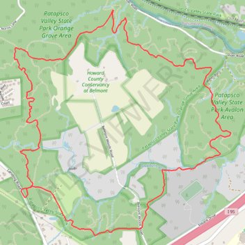
Name: Patapsco Valley State Park - Orange Grove Area trail, distance, elevation, map, profile, GPS track
Coordinates: 39.21381 -76.75309 39.23217 -76.73044
Topography: Columbia topographic map, elevation, terrain
Other hiking, mountain biking, running and outdoor activity trails
Click on a trail to view its statistics, map and profile.
Patapsco Valley State Park - Orange Grove Area Loop
United States > Maryland > Howard County > Columbia
Distance: 7.1 mi • Elevation gain: 758 ft • Maximum elevation: 384 ft
Cascade Falls Loop Trail in Patapsco Valley State Park
United States > Maryland > Howard County > Elkridge
Distance: 3.9 mi • Elevation gain: 407 ft • Maximum elevation: 384 ft
Elkridge - Rockburn Branch Park
United States > Maryland > Howard County > Columbia
Distance: 2.9 mi • Elevation gain: 157 ft • Maximum elevation: 341 ft
Rockburn Branch Park Loop - Elkridge
United States > Maryland > Howard County > Columbia
Distance: 5.0 mi • Elevation gain: 272 ft • Maximum elevation: 367 ft