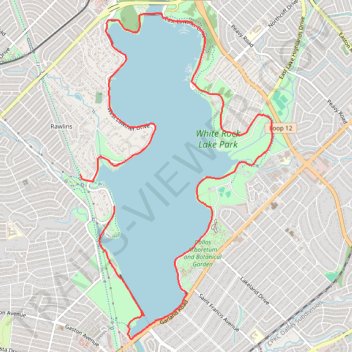
White Rock Lake Loop
- Distance: 9.0 mi
- Elevation gain: 256 ft
- Maximum elevation: 502 ft
- Elevation loss: 233 ft
- Minimum elevation: 427 ft
- Moving time: 1 h 8 m
- Moving speed: 7.9 mph
- Maximum speed: 20.1 mph
- Total time: 1 h 11 m
- Global speed: 7.6 mph
Interactive trail map
Trail profile
- Distance: 9.0 mi
- Elevation gain: 256 ft
- Maximum elevation: 502 ft
- Elevation loss: 233 ft
- Minimum elevation: 427 ft
- Moving time: 1 h 8 m
- Moving speed: 7.9 mph
- Maximum speed: 20.1 mph
- Total time: 1 h 11 m
- Global speed: 7.6 mph
About this trail
Name: White Rock Lake Loop trail, distance, elevation, map, profile, GPS track
Start: White Rock Lake Trail, Dallas, Dallas County, Texas, 75214, United States (32.82871 -96.72920)
End: SoPac Trail, Rawlins, Dallas, Dallas County, Texas, 75214, United States (32.83245 -96.73400)
Coordinates: 32.81308 -96.73400 32.85147 -96.70710
Topography: Dallas topographic map, elevation, terrain
Other hiking, mountain biking, running and outdoor activity trails
Click on a trail to view its statistics, map and profile.
Cycling in Dallas and Park Cities
United States > Texas > Dallas County > Dallas > Gifford
Distance: 26.8 mi • Elevation gain: 922 ft • Maximum elevation: 640 ft
White Rock Lake Park
United States > Texas > Dallas County > Dallas
Distance: 11.2 mi • Elevation gain: 394 ft • Maximum elevation: 531 ft