Ramapo Valley County Reservation Loop Hike: Scarlet Oak Pond, Bald Mountain, Bear Swamp Lake, MacMillan Reservoir
Starting from the Darlington side of Ramapo Valley County Reservation, this loop follows Vista Spur Trail toward the Ramapo River before joining Pond Loop Trail beside Scarlet Oak Pond. The route soon leaves the water on Vista Loop, climbing through the forest to Hawk Rock and Cactus Ledge, where open rock ledges frame the wooded Ramapo Valley and the pond below.
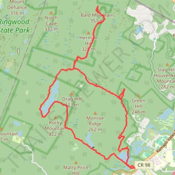
Beyond the vista area, the hike continues on Halifax Trail toward the Havemeyer Reservoir Basin, then follows Woods Road into the quieter northern part of the Ramapo Mountains. This more secluded section leads to Bald Mountain, giving the itinerary a wilder ridge-and-woodland character before it turns back south.
The return links Halifax Trail and Hoeferlin Memorial Trail toward Bear Swamp Lake, then follows Shore Trail and Rocky Mountain Connector through a landscape of lakeside forest, rocky slopes and sheltered wetlands. Ridge Loop Trail and MacMillan Reservoir add another scenic water feature before Vista-Ridge Connector, Pond Loop Trail and Vista Spur Trail bring the route back past Scarlet Oak Pond and the Ramapo River lowlands to the trailhead.
#Hiking #Loop #Forest #Lake #Pond #Reservoir #Ridge #Mountain #Nature
- Distance: 12.0 mi
- Elevation gain: 1,719 ft
- Maximum elevation: 1,152 ft
- Elevation loss: 1,722 ft
- Minimum elevation: 230 ft
- Moving time: 4 h 24 m
- Moving speed: 2.7 mph
- Maximum speed: 10.6 mph
- Total time: 5 h 7 m
- Global speed: 2.4 mph
Interactive trail map
Trail profile
- Distance: 12.0 mi
- Elevation gain: 1,719 ft
- Maximum elevation: 1,152 ft
- Elevation loss: 1,722 ft
- Minimum elevation: 230 ft
- Moving time: 4 h 24 m
- Moving speed: 2.7 mph
- Maximum speed: 10.6 mph
- Total time: 5 h 7 m
- Global speed: 2.4 mph
About this trail
Name: Ramapo Valley County Reservation Loop Hike: Scarlet Oak Pond, Bald Mountain, Bear Swamp Lake, MacMillan Reservoir trail, distance, elevation, map, profile, GPS track
Coordinates: 41.07770 -74.22086 41.12148 -74.18670
Topography: Bergen County topographic map, elevation, terrain
Other hiking, mountain biking, running and outdoor activity trails
Click on a trail to view its statistics, map and profile.
Vista Loop Trail via Scarlet Oak Pond, Hawk Rock, Cactus Ledge, Ridge Overlook, MacMillan Reservoir and MacMillan Brook Falls in Ramapo Valley County Reservation
United States > New Jersey > Bergen County > Mahwah > Darlington
This loop provides a scenic hike with varied landscapes, beginning along the serene shores of Scarlet Oak Pond and climbing to viewpoints like Hawk Rock and Cactus Ledge, where sweeping views extend across Bergen County and, on clear days, toward the New York City skyline. This trail is highlighted by its…
Distance: 3.5 mi • Elevation gain: 741 ft • Maximum elevation: 820 ft
Loop Hike to Bear Swamp Lake in Ramapo Valley County Reservation
United States > New Jersey > Bergen County > Mahwah > Darlington
Distance: 7.3 mi • Elevation gain: 1,148 ft • Maximum elevation: 883 ft
Ringwood State Park
United States > New Jersey > Passaic County > Ringwood > Erskine Lakes
Distance: 7.6 mi • Elevation gain: 1,014 ft • Maximum elevation: 1,073 ft