Thank you for supporting this site ❤️
Make a donation
Make a donation
Gear up for your next adventure:
As an Amazon Associate, this site earns from qualifying purchases at no extra cost to you.
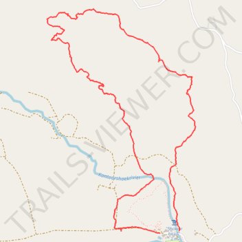
Gifboom Loop Trail
- Distance: 4.8 mi
- Elevation gain: 876 ft
- Maximum elevation: 1,755 ft
- Elevation loss: 853 ft
- Minimum elevation: 1,122 ft
- Moving time: 3 h 5 m
- Moving speed: 1.6 mph
- Maximum speed: 6.2 mph
- Total time: 5 h 6 m
- Global speed: 0.9 mph
Interactive trail map
Thank you for supporting this site ❤️
Make a donation
Make a donation
Gear up for your next adventure:
As an Amazon Associate, this site earns from qualifying purchases at no extra cost to you.
Trail profile
- Distance: 4.8 mi
- Elevation gain: 876 ft
- Maximum elevation: 1,755 ft
- Elevation loss: 853 ft
- Minimum elevation: 1,122 ft
- Moving time: 3 h 5 m
- Moving speed: 1.6 mph
- Maximum speed: 6.2 mph
- Total time: 5 h 6 m
- Global speed: 0.9 mph
Thank you for supporting this site ❤️
Make a donation
Make a donation
Gear up for your next adventure:
As an Amazon Associate, this site earns from qualifying purchases at no extra cost to you.
About this trail
Name: Gifboom Loop Trail trail, distance, elevation, map, profile, GPS track
Coordinates: -31.80918 18.77104 -31.78998 18.78606
Thank you for supporting this site ❤️
Make a donation
Make a donation
Gear up for your next adventure:
As an Amazon Associate, this site earns from qualifying purchases at no extra cost to you.