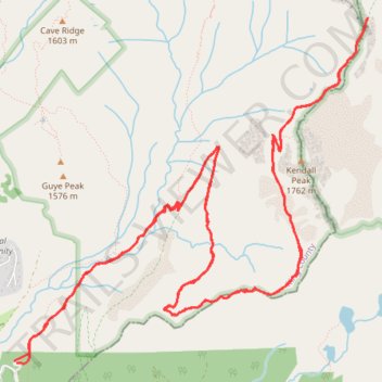
Old Commonwealth Trail to Kendall Katwalk
- Distance: 10.7 mi
- Elevation gain: 3,107 ft
- Maximum elevation: 5,482 ft
- Elevation loss: 3,097 ft
- Minimum elevation: 3,031 ft
- Moving time: 5 h 34 m
- Moving speed: 1.9 mph
- Maximum speed: 4.6 mph
- Total time: 6 h 39 m
- Global speed: 1.6 mph
Interactive trail map
Trail profile
- Distance: 10.7 mi
- Elevation gain: 3,107 ft
- Maximum elevation: 5,482 ft
- Elevation loss: 3,097 ft
- Minimum elevation: 3,031 ft
- Moving time: 5 h 34 m
- Moving speed: 1.9 mph
- Maximum speed: 4.6 mph
- Total time: 6 h 39 m
- Global speed: 1.6 mph
About this trail
Name: Old Commonwealth Trail to Kendall Katwalk trail, distance, elevation, map, profile, GPS track
Coordinates: 47.42916 -121.41378 47.45272 -121.37819
Topography: King County topographic map, elevation, terrain
Other hiking, mountain biking, running and outdoor activity trails
Click on a trail to view its statistics, map and profile.
Red Mountain and Red Pond via Pacific Crest Trail and Commonwealth Basin Trail
United States > Washington > Kittitas County > Snoqualmie Pass
The hike to Red Mountain and Red Pond in the Alpine Lakes Wilderness offers an engaging combination of lush forests, scenic meadows, and expansive mountain views. The route begins with a gradual climb through old-growth forests, followed by a steeper ascent as you approach the saddle between Red Mountain and…
Distance: 7.8 mi • Elevation gain: 3,005 ft • Maximum elevation: 5,646 ft
Northern part of the Pacific Crest Trail (PCT)
United States > Oregon > Klamath County
Hike on the Pacific Crest National Scenic Trail from Crater Lake to Canada Border through Oregon and Washington along the Sierra Nevada and Cascade mountain ranges. #Hiking #Mountain #SierraNevada #Cascade #Nature #Forest #Park #PCT
Distance: 744.6 mi • Elevation gain: 145,367 ft • Maximum elevation: 7,569 ft