Thank you for supporting this site ❤️
Make a donation
Make a donation
Gear up for your next adventure:
As an Amazon Associate, this site earns from qualifying purchases at no extra cost to you.
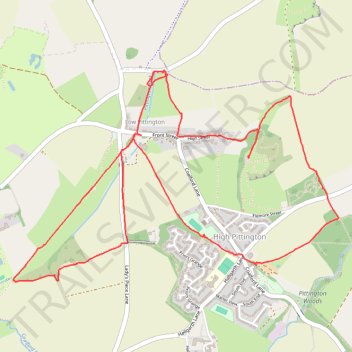
High and low Pitington loop
- Distance: 4.2 mi
- Elevation gain: 361 ft
- Maximum elevation: 512 ft
- Elevation loss: 364 ft
- Minimum elevation: 236 ft
- Moving time: 1 h 35 m
- Moving speed: 2.6 mph
- Maximum speed: 5.8 mph
- Total time: 1 h 49 m
- Global speed: 2.3 mph
Interactive trail map
Thank you for supporting this site ❤️
Make a donation
Make a donation
Gear up for your next adventure:
As an Amazon Associate, this site earns from qualifying purchases at no extra cost to you.
Trail profile
- Distance: 4.2 mi
- Elevation gain: 361 ft
- Maximum elevation: 512 ft
- Elevation loss: 364 ft
- Minimum elevation: 236 ft
- Moving time: 1 h 35 m
- Moving speed: 2.6 mph
- Maximum speed: 5.8 mph
- Total time: 1 h 49 m
- Global speed: 2.3 mph
Thank you for supporting this site ❤️
Make a donation
Make a donation
Gear up for your next adventure:
As an Amazon Associate, this site earns from qualifying purchases at no extra cost to you.
About this trail
Name: High and low Pitington loop trail, distance, elevation, map, profile, GPS track
Coordinates: 54.79030 -1.50616 54.80017 -1.47980
Thank you for supporting this site ❤️
Make a donation
Make a donation
Gear up for your next adventure:
As an Amazon Associate, this site earns from qualifying purchases at no extra cost to you.