Thank you for supporting this site ❤️
Make a donation
Make a donation
Gear up for your next adventure:
As an Amazon Associate, this site earns from qualifying purchases at no extra cost to you.
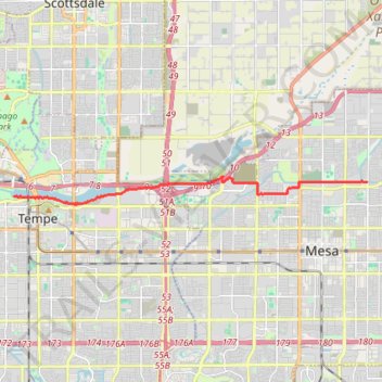
Mesa to Tempe Town Lake via stadium connector path
- Distance: 8.8 mi
- Elevation gain: 144 ft
- Maximum elevation: 1,273 ft
- Elevation loss: 249 ft
- Minimum elevation: 1,138 ft
Interactive trail map
Thank you for supporting this site ❤️
Make a donation
Make a donation
Gear up for your next adventure:
As an Amazon Associate, this site earns from qualifying purchases at no extra cost to you.
Trail profile
- Distance: 8.8 mi
- Elevation gain: 144 ft
- Maximum elevation: 1,273 ft
- Elevation loss: 249 ft
- Minimum elevation: 1,138 ft
Thank you for supporting this site ❤️
Make a donation
Make a donation
Gear up for your next adventure:
As an Amazon Associate, this site earns from qualifying purchases at no extra cost to you.
About this trail
Name: Mesa to Tempe Town Lake via stadium connector path trail, distance, elevation, map, profile, GPS track
Coordinates: 33.42979 -111.94893 33.43870 -111.81413
Topography: Mesa topographic map, elevation, terrain
Thank you for supporting this site ❤️
Make a donation
Make a donation
Gear up for your next adventure:
As an Amazon Associate, this site earns from qualifying purchases at no extra cost to you.