Make a donation
Gear up for your next adventure:
As an Amazon Associate, this site earns from qualifying purchases at no extra cost to you.
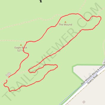
The Mound and Eagle Rock loop hike in Blue Mounds State Park
- Distance: 1.5 mi
- Elevation gain: 161 ft
- Maximum elevation: 1,706 ft
- Elevation loss: 151 ft
- Minimum elevation: 1,594 ft
- Moving time: 38 m 1 s
- Moving speed: 2.3 mph
- Maximum speed: 3.2 mph
- Total time: 39 m 11 s
- Global speed: 2.3 mph
Interactive trail map
Make a donation
Gear up for your next adventure:
As an Amazon Associate, this site earns from qualifying purchases at no extra cost to you.
Trail profile
- Distance: 1.5 mi
- Elevation gain: 161 ft
- Maximum elevation: 1,706 ft
- Elevation loss: 151 ft
- Minimum elevation: 1,594 ft
- Moving time: 38 m 1 s
- Moving speed: 2.3 mph
- Maximum speed: 3.2 mph
- Total time: 39 m 11 s
- Global speed: 2.3 mph
Make a donation
Gear up for your next adventure:
As an Amazon Associate, this site earns from qualifying purchases at no extra cost to you.
About this trail
Name: The Mound and Eagle Rock loop hike in Blue Mounds State Park trail, distance, elevation, map, profile, GPS track
Start: Park Road, Mound Township, Rock County, Minnesota, 56156, United States (43.69141 -96.19612)
End: Park Road, Mound Township, Rock County, Minnesota, 56156, United States (43.69160 -96.19595)
Coordinates: 43.69072 -96.19634 43.69556 -96.18799
Topography: Mound Township topographic map, elevation, terrain
Make a donation
Gear up for your next adventure:
As an Amazon Associate, this site earns from qualifying purchases at no extra cost to you.