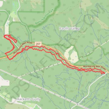
Kalamunda mtb green trails starting from camel farm
- Distance: 7.7 mi
- Elevation gain: 610 ft
- Maximum elevation: 1,030 ft
- Elevation loss: 610 ft
- Minimum elevation: 817 ft
- Moving time: 1 h 58 m
- Moving speed: 3.9 mph
- Maximum speed: 9.6 mph
- Total time: 2 h 43 m
- Global speed: 2.8 mph
Interactive trail map
Trail profile
- Distance: 7.7 mi
- Elevation gain: 610 ft
- Maximum elevation: 1,030 ft
- Elevation loss: 610 ft
- Minimum elevation: 817 ft
- Moving time: 1 h 58 m
- Moving speed: 3.9 mph
- Maximum speed: 9.6 mph
- Total time: 2 h 43 m
- Global speed: 2.8 mph
About this trail
Name: Kalamunda mtb green trails starting from camel farm trail, distance, elevation, map, profile, GPS track
Coordinates: -31.97608 116.10623 -31.96480 116.14044
Other hiking, mountain biking, running and outdoor activity trails
Click on a trail to view its statistics, map and profile.
01Bib_Kalamunda to Hewett Hill Campsite
01Bib_Kalamunda to Hewett Hill Campsite
Distance: 6.4 mi • Elevation gain: 938 ft • Maximum elevation: 968 ft
2021 Toodyay return via Kep
Distance: 142.9 mi • Elevation gain: 6,099 ft • Maximum elevation: 1,171 ft