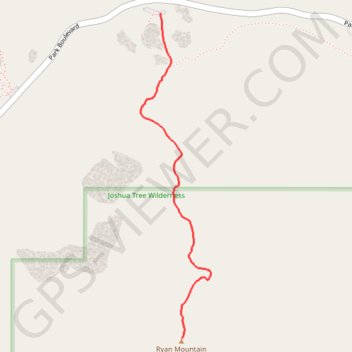
Ryan Mountain
Interactive trail map
Trail profile
- Distance: 1.4 mi
- Elevation gain: 1,060 ft
- Maximum elevation: 5,446 ft
- Elevation loss: 36 ft
- Minimum elevation: 4,406 ft
About this trail
Name: Ryan Mountain trail, distance, elevation, map, profile, GPS track
Start: Ryan Mountain Trail, Riverside County, California, United States (34.00260 -116.13592)
End: Ryan Mountain Trail, Riverside County, California, United States (33.98625 -116.13465)
Coordinates: 33.98625 -116.13714 34.00260 -116.13288
Topography: Riverside County topographic map, elevation, terrain
Other hiking, mountain biking, running and outdoor activity trails
Click on a trail to view its statistics, map and profile.
Ryan Mountain Trail in Joshua Tree National Park
United States > California > Riverside County
The Ryan Mountain Trail offers an exhilarating climb with dramatic, sweeping views across the Mojave Desert. As hikers ascend, they are greeted by striking rock formations, including ancient granite boulders, and the iconic Joshua trees scattered throughout the park’s vast landscape. From the summit, the…
Distance: 2.9 mi • Elevation gain: 1,060 ft • Maximum elevation: 5,446 ft