象山西石河
- Distance: 2.2 mi
- Elevation gain: 1,047 ft
- Maximum elevation: 820 ft
- Elevation loss: 262 ft
- Minimum elevation: 33 ft
- Moving time: 1 h 7 m
- Moving speed: 1.9 mph
- Maximum speed: 5.5 mph
- Total time: 2 h 11 s
- Global speed: 1.1 mph
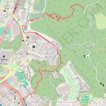
Interactive trail map
Trail profile
- Distance: 2.2 mi
- Elevation gain: 1,047 ft
- Maximum elevation: 820 ft
- Elevation loss: 262 ft
- Minimum elevation: 33 ft
- Moving time: 1 h 7 m
- Moving speed: 1.9 mph
- Maximum speed: 5.5 mph
- Total time: 2 h 11 s
- Global speed: 1.1 mph
About this trail
Name: 象山西石河 trail, distance, elevation, map, profile, GPS track
Start: Ngau Chi Wan, Wong Tai Sin District, Kowloon, Hong Kong, China (22.33552 114.20795)
End: Jat's Incline, Hammer Hill, Wong Tai Sin District, Kowloon, Hong Kong, China (22.34580 114.21511)
Coordinates: 22.33552 114.20761 22.34656 114.21511
Other hiking, mountain biking, running and outdoor activity trails
Click on a trail to view its statistics, map and profile.
城門~北潭坳
China > Hong Kong > Tsuen Wan District > Kwai Chung > Lower Shing Mun Village
ShingMunReservoir~PakTamAu
Distance: 23.3 mi • Elevation gain: 7,156 ft • Maximum elevation: 1,808 ft
Wilson Trail Full Route
China > Hong Kong > Hong Kong Island
Distance: 50.5 mi • Elevation gain: 14,534 ft • Maximum elevation: 2,011 ft