Make a donation
Gear up for your next adventure:
As an Amazon Associate, this site earns from qualifying purchases at no extra cost to you.
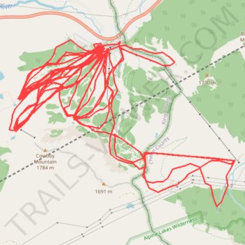
Stevens Pass Ski Area
- Distance: 54.8 mi
- Elevation gain: 27,293 ft
- Maximum elevation: 5,256 ft
- Elevation loss: 27,316 ft
- Minimum elevation: 3,839 ft
Interactive trail map
Make a donation
Gear up for your next adventure:
As an Amazon Associate, this site earns from qualifying purchases at no extra cost to you.
Trail profile
- Distance: 54.8 mi
- Elevation gain: 27,293 ft
- Maximum elevation: 5,256 ft
- Elevation loss: 27,316 ft
- Minimum elevation: 3,839 ft
Make a donation
Gear up for your next adventure:
As an Amazon Associate, this site earns from qualifying purchases at no extra cost to you.
About this trail
Name: Stevens Pass Ski Area trail, distance, elevation, map, profile, GPS track
Start: 3, US 2, King County, Washington, United States (47.74414 -121.09337)
End: 2, US 2, King County, Washington, United States (47.74445 -121.09264)
Coordinates: 47.72550 -121.10836 47.74523 -121.06956
Topography: King County topographic map, elevation, terrain
Make a donation
Gear up for your next adventure:
As an Amazon Associate, this site earns from qualifying purchases at no extra cost to you.
Other hiking, mountain biking, running and outdoor activity trails
Click on a trail to view its statistics, map and profile.
Northern part of the Pacific Crest Trail (PCT)
United States > Oregon > Klamath County
Hike on the Pacific Crest National Scenic Trail from Crater Lake to Canada Border through Oregon and Washington along the Sierra Nevada and Cascade mountain ranges. #Hiking #Mountain #SierraNevada #Cascade #Nature #Forest #Park #PCT
Distance: 744.6 mi • Elevation gain: 145,367 ft • Maximum elevation: 7,569 ft