Make a donation
Gear up for your next adventure:
As an Amazon Associate, this site earns from qualifying purchases at no extra cost to you.
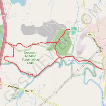
Morning round trip around Nashua River from Lancaster
Lancaster Trails, Cook Conservation Area, Nashua River, Chapman-Goodale Conservation Land, Lancaster State Forest
- Distance: 5.7 mi
- Elevation gain: 299 ft
- Maximum elevation: 377 ft
- Elevation loss: 299 ft
- Minimum elevation: 249 ft
- Moving time: 1 h 53 m
- Moving speed: 3.0 mph
- Maximum speed: 8.8 mph
- Total time: 1 h 59 m
- Global speed: 2.9 mph
Interactive trail map
Make a donation
Gear up for your next adventure:
As an Amazon Associate, this site earns from qualifying purchases at no extra cost to you.
Trail profile
- Distance: 5.7 mi
- Elevation gain: 299 ft
- Maximum elevation: 377 ft
- Elevation loss: 299 ft
- Minimum elevation: 249 ft
- Moving time: 1 h 53 m
- Moving speed: 3.0 mph
- Maximum speed: 8.8 mph
- Total time: 1 h 59 m
- Global speed: 2.9 mph
Make a donation
Gear up for your next adventure:
As an Amazon Associate, this site earns from qualifying purchases at no extra cost to you.
About this trail
Name: Morning round trip around Nashua River from Lancaster trail, distance, elevation, map, profile, GPS track
Coordinates: 42.49192 -71.72107 42.50429 -71.68652
Topography: Worcester County topographic map, elevation, terrain
Make a donation
Gear up for your next adventure:
As an Amazon Associate, this site earns from qualifying purchases at no extra cost to you.
Other hiking, mountain biking, running and outdoor activity trails
Click on a trail to view its statistics, map and profile.
Loop in Eastern Mass involving various rail trails
United States > Massachusetts > Middlesex County > Newton
Distance: 126.6 mi • Elevation gain: 6,365 ft • Maximum elevation: 636 ft