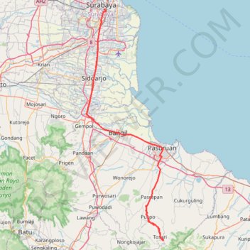
Balai kota surabaya - pendopo wonokitri via alun2
- Distance: 64.1 mi
- Elevation gain: 7,293 ft
- Maximum elevation: 6,178 ft
- Elevation loss: 1,135 ft
- Minimum elevation: 7 ft
Interactive trail map
Trail profile
- Distance: 64.1 mi
- Elevation gain: 7,293 ft
- Maximum elevation: 6,178 ft
- Elevation loss: 1,135 ft
- Minimum elevation: 7 ft
About this trail
Name: Balai kota surabaya - pendopo wonokitri via alun2 trail, distance, elevation, map, profile, GPS track
End: Wonokitri, Pasuruan, East Java, Java, 67177, Indonesia (-7.89235 112.91131)
Coordinates: -7.89511 112.69742 -7.25950 112.91131
Other hiking, mountain biking, running and outdoor activity trails
Click on a trail to view its statistics, map and profile.
BENTANGJAWA2024_FINAL
Indonesia > West Java > Sukabumi > Tegalbuleud > Panaruban
Distance: 712.8 mi • Elevation gain: 40,381 ft • Maximum elevation: 8,071 ft