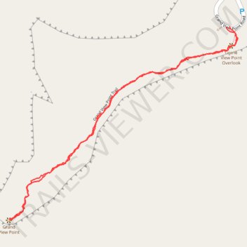
Grand View Point Trail in Canyonlands National Park
The Grand View Point Trail in Canyonlands National Park offers hikers breathtaking vistas of the expansive canyons and mesas that define the Island in the Sky district. As you traverse the trail, you'll encounter panoramic views of the White Rim Road, the confluence of the Colorado and Green Rivers, and distant mountain ranges like La Sal Mountains. The trail is well-marked with cairns and provides a relatively flat, accessible path to some of the most stunning overlooks in the park. #Hiking #Canyon #Desert #Nature #Rock #Overlook
- Distance: 2.0 mi
- Elevation gain: 1,342 ft
- Maximum elevation: 6,296 ft
- Elevation loss: 1,339 ft
- Minimum elevation: 6,043 ft
- Moving time: 52 m 55 s
- Moving speed: 2.3 mph
- Maximum speed: 4.5 mph
- Total time: 1 h 9 m
- Global speed: 1.7 mph
Interactive trail map
Trail profile
- Distance: 2.0 mi
- Elevation gain: 1,342 ft
- Maximum elevation: 6,296 ft
- Elevation loss: 1,339 ft
- Minimum elevation: 6,043 ft
- Moving time: 52 m 55 s
- Moving speed: 2.3 mph
- Maximum speed: 4.5 mph
- Total time: 1 h 9 m
- Global speed: 1.7 mph
About this trail
Name: Grand View Point Trail in Canyonlands National Park trail, distance, elevation, map, profile, GPS track
Coordinates: 38.30336 -109.86779 38.31090 -109.85643
Topography: San Juan County topographic map, elevation, terrain