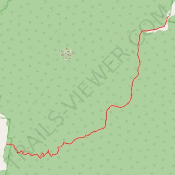
Reubens Creek Trail
- Distance: 10.8 mi
- Elevation gain: 1,683 ft
- Maximum elevation: 1,627 ft
- Elevation loss: 1,693 ft
- Minimum elevation: 787 ft
- Moving time: 2 h 22 m
- Moving speed: 4.5 mph
- Maximum speed: 8.1 mph
- Total time: 2 h 25 m
- Global speed: 4.4 mph
Interactive trail map
Trail profile
- Distance: 10.8 mi
- Elevation gain: 1,683 ft
- Maximum elevation: 1,627 ft
- Elevation loss: 1,693 ft
- Minimum elevation: 787 ft
- Moving time: 2 h 22 m
- Moving speed: 4.5 mph
- Maximum speed: 8.1 mph
- Total time: 2 h 25 m
- Global speed: 4.4 mph
About this trail
Name: Reubens Creek Trail trail, distance, elevation, map, profile, GPS track
Coordinates: -32.60385 150.38367 -32.56722 150.43327
Other hiking, mountain biking, running and outdoor activity trails
Click on a trail to view its statistics, map and profile.
Broadmeadow - Gulgong - Merrygoen - Dubbo railway
Australia > New South Wales > Newcastle
AU, NSW, railway
Distance: 232.6 mi • Elevation gain: 8,645 ft • Maximum elevation: 1,654 ft
Broadmeadow - Gulgong - Merrygoen - Dubbo railway
Australia > New South Wales > Newcastle
AU, NSW, railway
Distance: 233.2 mi • Elevation gain: 8,665 ft • Maximum elevation: 1,696 ft