Thank you for supporting this site ❤️
Make a donation
Make a donation
Gear up for your next adventure:
As an Amazon Associate, this site earns from qualifying purchases at no extra cost to you.
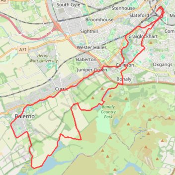
Ride up to Pentland Hills Regional Park
- Distance: 18.8 mi
- Elevation gain: 1,161 ft
- Maximum elevation: 942 ft
- Elevation loss: 1,161 ft
- Minimum elevation: 207 ft
- Moving time: 1 h 37 m
- Moving speed: 11.6 mph
- Maximum speed: 29.9 mph
- Total time: 1 h 39 m
- Global speed: 11.3 mph
Interactive trail map
Thank you for supporting this site ❤️
Make a donation
Make a donation
Gear up for your next adventure:
As an Amazon Associate, this site earns from qualifying purchases at no extra cost to you.
Trail profile
- Distance: 18.8 mi
- Elevation gain: 1,161 ft
- Maximum elevation: 942 ft
- Elevation loss: 1,161 ft
- Minimum elevation: 207 ft
- Moving time: 1 h 37 m
- Moving speed: 11.6 mph
- Maximum speed: 29.9 mph
- Total time: 1 h 39 m
- Global speed: 11.3 mph
Thank you for supporting this site ❤️
Make a donation
Make a donation
Gear up for your next adventure:
As an Amazon Associate, this site earns from qualifying purchases at no extra cost to you.
About this trail
Name: Ride up to Pentland Hills Regional Park trail, distance, elevation, map, profile, GPS track
Coordinates: 55.86016 -3.35001 55.93365 -3.22583
Thank you for supporting this site ❤️
Make a donation
Make a donation
Gear up for your next adventure:
As an Amazon Associate, this site earns from qualifying purchases at no extra cost to you.
Other hiking, mountain biking, running and outdoor activity trails
Click on a trail to view its statistics, map and profile.
Cycleroute Edinburgh
United Kingdom > Scotland > City of Edinburgh
Summer!
Distance: 47.5 mi • Elevation gain: 2,907 ft • Maximum elevation: 1,066 ft