Thank you for supporting this site ❤️
Make a donation
Make a donation
Gear up for your next adventure:
As an Amazon Associate, this site earns from qualifying purchases at no extra cost to you.
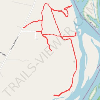
Trails north of Stillwater along Saint Croix River
- Distance: 4.4 mi
- Elevation gain: 525 ft
- Maximum elevation: 899 ft
- Elevation loss: 525 ft
- Minimum elevation: 692 ft
- Moving time: 57 m 48 s
- Moving speed: 4.6 mph
- Maximum speed: 9.8 mph
- Total time: 1 h 7 m
- Global speed: 3.9 mph
Interactive trail map
Thank you for supporting this site ❤️
Make a donation
Make a donation
Gear up for your next adventure:
As an Amazon Associate, this site earns from qualifying purchases at no extra cost to you.
Trail profile
- Distance: 4.4 mi
- Elevation gain: 525 ft
- Maximum elevation: 899 ft
- Elevation loss: 525 ft
- Minimum elevation: 692 ft
- Moving time: 57 m 48 s
- Moving speed: 4.6 mph
- Maximum speed: 9.8 mph
- Total time: 1 h 7 m
- Global speed: 3.9 mph
Thank you for supporting this site ❤️
Make a donation
Make a donation
Gear up for your next adventure:
As an Amazon Associate, this site earns from qualifying purchases at no extra cost to you.
About this trail
Name: Trails north of Stillwater along Saint Croix River trail, distance, elevation, map, profile, GPS track
Coordinates: 45.11049 -92.75446 45.12233 -92.74475
Topography: Stillwater Township topographic map, elevation, terrain
Thank you for supporting this site ❤️
Make a donation
Make a donation
Gear up for your next adventure:
As an Amazon Associate, this site earns from qualifying purchases at no extra cost to you.