Thank you for supporting this site ❤️
Make a donation
Make a donation
Gear up for your next adventure:
As an Amazon Associate, this site earns from qualifying purchases at no extra cost to you.
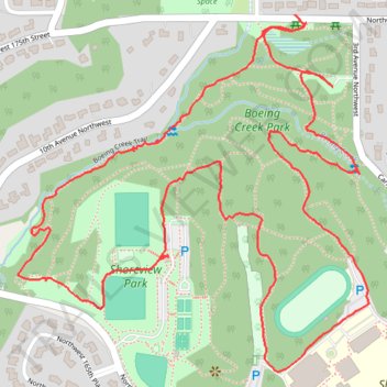
Boeing Creek Park Loop
- Distance: 2.4 mi
- Elevation gain: 302 ft
- Maximum elevation: 476 ft
- Elevation loss: 305 ft
- Minimum elevation: 233 ft
- Moving time: 1 h 11 m
- Moving speed: 2.1 mph
- Maximum speed: 4.7 mph
- Total time: 1 h 30 m
- Global speed: 1.6 mph
Interactive trail map
Thank you for supporting this site ❤️
Make a donation
Make a donation
Gear up for your next adventure:
As an Amazon Associate, this site earns from qualifying purchases at no extra cost to you.
Trail profile
- Distance: 2.4 mi
- Elevation gain: 302 ft
- Maximum elevation: 476 ft
- Elevation loss: 305 ft
- Minimum elevation: 233 ft
- Moving time: 1 h 11 m
- Moving speed: 2.1 mph
- Maximum speed: 4.7 mph
- Total time: 1 h 30 m
- Global speed: 1.6 mph
Thank you for supporting this site ❤️
Make a donation
Make a donation
Gear up for your next adventure:
As an Amazon Associate, this site earns from qualifying purchases at no extra cost to you.
About this trail
Name: Boeing Creek Park Loop trail, distance, elevation, map, profile, GPS track
Coordinates: 47.74945 -122.37045 47.75605 -122.36081
Topography: King County topographic map, elevation, terrain
Thank you for supporting this site ❤️
Make a donation
Make a donation
Gear up for your next adventure:
As an Amazon Associate, this site earns from qualifying purchases at no extra cost to you.