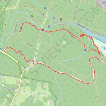
Borehole Colliery No.1 site
- Distance: 2.6 mi
- Elevation gain: 407 ft
- Maximum elevation: 315 ft
- Elevation loss: 433 ft
- Minimum elevation: 13 ft
- Moving time: 1 h 3 m
- Moving speed: 2.5 mph
- Maximum speed: 4.4 mph
- Total time: 1 h 50 m
- Global speed: 1.4 mph
Interactive trail map
Trail profile
- Distance: 2.6 mi
- Elevation gain: 407 ft
- Maximum elevation: 315 ft
- Elevation loss: 433 ft
- Minimum elevation: 13 ft
- Moving time: 1 h 3 m
- Moving speed: 2.5 mph
- Maximum speed: 4.4 mph
- Total time: 1 h 50 m
- Global speed: 1.4 mph
About this trail
Name: Borehole Colliery No.1 site trail, distance, elevation, map, profile, GPS track
Coordinates: -32.96572 151.71956 -32.95944 151.73160
Other hiking, mountain biking, running and outdoor activity trails
Click on a trail to view its statistics, map and profile.
Broadmeadow - Readhead Beach - Belmont
Australia > New South Wales > Newcastle-Maitland
Fernleigh Track. #Bike
Distance: 22.8 mi • Elevation gain: 866 ft • Maximum elevation: 322 ft
Teralba - Newcastle
Australia > New South Wales > Newcastle-Maitland
Distance: 15.8 mi • Elevation gain: 1,191 ft • Maximum elevation: 351 ft
Fernleigh Rail Trail
Australia > New South Wales > Newcastle-Maitland > Belmont
#Bike
Distance: 13.1 mi • Elevation gain: 525 ft • Maximum elevation: 322 ft