Thank you for supporting this site ❤️
Make a donation
Make a donation
Gear up for your next adventure:
As an Amazon Associate, this site earns from qualifying purchases at no extra cost to you.
Umiray-Pilipit Boat Ride
- Distance: 20.3 mi
- Elevation gain: 1,184 ft
- Maximum elevation: 308 ft
- Elevation loss: 978 ft
- Minimum elevation: 7 ft
- Moving time: 3 h 6 m
- Moving speed: 6.5 mph
- Maximum speed: 31.3 mph
- Total time: 3 h 35 m
- Global speed: 5.6 mph
Interactive trail map
Thank you for supporting this site ❤️
Make a donation
Make a donation
Gear up for your next adventure:
As an Amazon Associate, this site earns from qualifying purchases at no extra cost to you.
Trail profile
- Distance: 20.3 mi
- Elevation gain: 1,184 ft
- Maximum elevation: 308 ft
- Elevation loss: 978 ft
- Minimum elevation: 7 ft
- Moving time: 3 h 6 m
- Moving speed: 6.5 mph
- Maximum speed: 31.3 mph
- Total time: 3 h 35 m
- Global speed: 5.6 mph
Thank you for supporting this site ❤️
Make a donation
Make a donation
Gear up for your next adventure:
As an Amazon Associate, this site earns from qualifying purchases at no extra cost to you.
About this trail
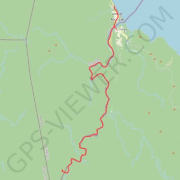
Name: Umiray-Pilipit Boat Ride trail, distance, elevation, map, profile, GPS track
Start: Malakwayan, Umiray, Dingalan, Aurora, Central Luzon, 3207, Philippines (15.23329 121.40807)
End: Dingalan, Aurora, Central Luzon, Philippines (15.06280 121.35212)
Coordinates: 15.05888 121.35123 15.23331 121.41259
Thank you for supporting this site ❤️
Make a donation
Make a donation
Gear up for your next adventure:
As an Amazon Associate, this site earns from qualifying purchases at no extra cost to you.