Thank you for supporting this site ❤️
Make a donation
Make a donation
Gear up for your next adventure:
As an Amazon Associate, this site earns from qualifying purchases at no extra cost to you.
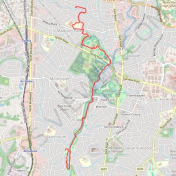
To the pool and back by the new greenway
Junction of LSC and Little Hope Creek Greenways
- Distance: 9.0 mi
- Elevation gain: 561 ft
- Maximum elevation: 696 ft
- Elevation loss: 561 ft
- Minimum elevation: 561 ft
- Moving time: 1 h 6 s
- Moving speed: 9.0 mph
- Maximum speed: 18.7 mph
- Total time: 3 h 43 m
- Global speed: 2.4 mph
Interactive trail map
Thank you for supporting this site ❤️
Make a donation
Make a donation
Gear up for your next adventure:
As an Amazon Associate, this site earns from qualifying purchases at no extra cost to you.
Trail profile
- Distance: 9.0 mi
- Elevation gain: 561 ft
- Maximum elevation: 696 ft
- Elevation loss: 561 ft
- Minimum elevation: 561 ft
- Moving time: 1 h 6 s
- Moving speed: 9.0 mph
- Maximum speed: 18.7 mph
- Total time: 3 h 43 m
- Global speed: 2.4 mph
Thank you for supporting this site ❤️
Make a donation
Make a donation
Gear up for your next adventure:
As an Amazon Associate, this site earns from qualifying purchases at no extra cost to you.
About this trail
Name: To the pool and back by the new greenway trail, distance, elevation, map, profile, GPS track
Coordinates: 35.13011 -80.86581 35.17047 -80.85192
Topography: Charlotte topographic map, elevation, terrain
Thank you for supporting this site ❤️
Make a donation
Make a donation
Gear up for your next adventure:
As an Amazon Associate, this site earns from qualifying purchases at no extra cost to you.