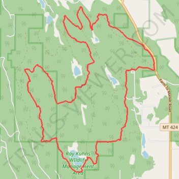
Pig Trail System
- Distance: 13.0 mi
- Elevation gain: 1,555 ft
- Maximum elevation: 3,786 ft
- Elevation loss: 1,555 ft
- Minimum elevation: 3,058 ft
- Moving time: 4 h 28 m
- Moving speed: 2.9 mph
- Maximum speed: 4.9 mph
- Total time: 4 h 47 m
- Global speed: 2.7 mph
Interactive trail map
Trail profile
- Distance: 13.0 mi
- Elevation gain: 1,555 ft
- Maximum elevation: 3,786 ft
- Elevation loss: 1,555 ft
- Minimum elevation: 3,058 ft
- Moving time: 4 h 28 m
- Moving speed: 2.9 mph
- Maximum speed: 4.9 mph
- Total time: 4 h 47 m
- Global speed: 2.7 mph
About this trail
Name: Pig Trail System trail, distance, elevation, map, profile, GPS track
Start: 1, Farm To Market Road, Flathead County, Montana, United States (48.33111 -114.42359)
End: 1, Farm To Market Road, Flathead County, Montana, United States (48.33110 -114.42345)
Coordinates: 48.30498 -114.47303 48.34725 -114.42318
Topography: Flathead County topographic map, elevation, terrain