Make a donation
Gear up for your next adventure:
As an Amazon Associate, this site earns from qualifying purchases at no extra cost to you.
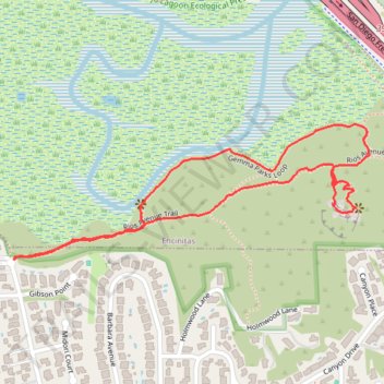
Annies Canyon Trail and Gemma Parks Loop in San Elijo Lagoon Ecological Reserve
Embarking from the Rios Trailhead, the combined Annie's Canyon Trail and Gemma Parks Loop offers hikers an immersive journey through the diverse landscapes of the San Elijo Lagoon Ecological Reserve. The route showcases vibrant wetlands teeming with birdlife, leading to the captivating sandstone slot canyon of Annie's Canyon, where narrow passages reveal the intricate artistry of natural erosion. Ascending to the canyon's viewpoint, visitors are rewarded with expansive vistas of the lagoon and the Pacific Ocean beyond. #Hiking #Loop #Canyon #Forest #River #Overlook #Nature
- Distance: 1.6 mi
- Elevation gain: 220 ft
- Maximum elevation: 161 ft
- Elevation loss: 220 ft
- Minimum elevation: 0 ft
- Moving time: 45 m 25 s
- Moving speed: 2.1 mph
- Maximum speed: 3.2 mph
- Total time: 53 m 5 s
- Global speed: 1.8 mph
Interactive trail map
Make a donation
Gear up for your next adventure:
As an Amazon Associate, this site earns from qualifying purchases at no extra cost to you.
Trail profile
- Distance: 1.6 mi
- Elevation gain: 220 ft
- Maximum elevation: 161 ft
- Elevation loss: 220 ft
- Minimum elevation: 0 ft
- Moving time: 45 m 25 s
- Moving speed: 2.1 mph
- Maximum speed: 3.2 mph
- Total time: 53 m 5 s
- Global speed: 1.8 mph
Make a donation
Gear up for your next adventure:
As an Amazon Associate, this site earns from qualifying purchases at no extra cost to you.
About this trail
Name: Annies Canyon Trail and Gemma Parks Loop in San Elijo Lagoon Ecological Reserve trail, distance, elevation, map, profile, GPS track
Coordinates: 33.00366 -117.27242 33.00669 -117.26293
Topography: Solana Beach topographic map, elevation, terrain
Make a donation
Gear up for your next adventure:
As an Amazon Associate, this site earns from qualifying purchases at no extra cost to you.
Other hiking, mountain biking, running and outdoor activity trails
Click on a trail to view its statistics, map and profile.
Annie's Canyon Trail via Solana Hills Trail, Rios Avenue Trail and Gemma Parks Loop
United States > California > San Diego County > Solana Beach
The hike along Solana Hills Trail, Rios Avenue Trail, and Gemma Parks Loop to Annie’s Canyon in the San Elijo Lagoon Ecological Reserve offers a serene blend of coastal wetlands, native chaparral, and sculpted sandstone canyons. As you meander through the trails, you'll encounter sweeping views of the…
Distance: 2.4 mi • Elevation gain: 427 ft • Maximum elevation: 253 ft