Make a donation
Gear up for your next adventure:
As an Amazon Associate, this site earns from qualifying purchases at no extra cost to you.
Morning hike at Island Creek Forest Walk Trail
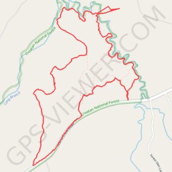
Croatan National Forest Loop
- Distance: 4.5 mi
- Elevation gain: 125 ft
- Maximum elevation: 66 ft
- Elevation loss: 125 ft
- Minimum elevation: 23 ft
Interactive trail map
Make a donation
Gear up for your next adventure:
As an Amazon Associate, this site earns from qualifying purchases at no extra cost to you.
Trail profile
- Distance: 4.5 mi
- Elevation gain: 125 ft
- Maximum elevation: 66 ft
- Elevation loss: 125 ft
- Minimum elevation: 23 ft
Make a donation
Gear up for your next adventure:
As an Amazon Associate, this site earns from qualifying purchases at no extra cost to you.
About this trail
Name: Morning hike at Island Creek Forest Walk Trail trail, distance, elevation, map, profile, GPS track
Coordinates: 35.02083 -77.14733 35.03614 -77.13490
Topography: Jones County topographic map, elevation, terrain
Make a donation
Gear up for your next adventure:
As an Amazon Associate, this site earns from qualifying purchases at no extra cost to you.
Other hiking, mountain biking, running and outdoor activity trails
Click on a trail to view its statistics, map and profile.
Island Creek Forest Walk Trail
United States > North Carolina > Jones County
Distance: 5.8 mi • Elevation gain: 105 ft • Maximum elevation: 66 ft
Afternoon hike at Island Creek Forest Walk Trail
United States > North Carolina > Jones County
Distance: 1.9 mi • Elevation gain: 69 ft • Maximum elevation: 66 ft
Island Creek Forest Loop Walk
United States > North Carolina > Jones County
Distance: 2.7 mi • Elevation gain: 59 ft • Maximum elevation: 66 ft
Island Creek
United States > North Carolina > Jones County
Morning hike at Island Creek Forest Walk Trail
Distance: 2.8 mi • Elevation gain: 75 ft • Maximum elevation: 66 ft
Make a donation
Gear up for your next adventure:
As an Amazon Associate, this site earns from qualifying purchases at no extra cost to you.
Island Creek Loop B (yellow)
United States > North Carolina > Jones County
Distance: 1.4 mi • Elevation gain: 43 ft • Maximum elevation: 69 ft