Make a donation
Gear up for your next adventure:
As an Amazon Associate, this site earns from qualifying purchases at no extra cost to you.
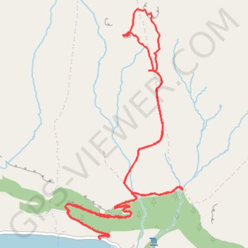
Walk to the Doneens & top of Glencarr Waterfall
Glencarr Wood Walk
- Distance: 5.5 mi
- Elevation gain: 1,335 ft
- Maximum elevation: 1,391 ft
- Elevation loss: 1,339 ft
- Minimum elevation: 128 ft
- Moving time: 2 h 4 m
- Moving speed: 2.6 mph
- Maximum speed: 5.8 mph
- Total time: 2 h 29 m
- Global speed: 2.2 mph
Interactive trail map
Make a donation
Gear up for your next adventure:
As an Amazon Associate, this site earns from qualifying purchases at no extra cost to you.
Trail profile
- Distance: 5.5 mi
- Elevation gain: 1,335 ft
- Maximum elevation: 1,391 ft
- Elevation loss: 1,339 ft
- Minimum elevation: 128 ft
- Moving time: 2 h 4 m
- Moving speed: 2.6 mph
- Maximum speed: 5.8 mph
- Total time: 2 h 29 m
- Global speed: 2.2 mph
Make a donation
Gear up for your next adventure:
As an Amazon Associate, this site earns from qualifying purchases at no extra cost to you.
About this trail
Name: Walk to the Doneens & top of Glencarr Waterfall trail, distance, elevation, map, profile, GPS track
Start: Glencar ED, Manorhamilton Municipal District, County Leitrim, Connacht, Ireland (54.34084 -8.37501)
Coordinates: 54.34073 -8.37938 54.35856 -8.36382
Make a donation
Gear up for your next adventure:
As an Amazon Associate, this site earns from qualifying purchases at no extra cost to you.
Other hiking, mountain biking, running and outdoor activity trails
Click on a trail to view its statistics, map and profile.
CTS-N.Irelandv1.1-Belfast-Titanic>Enniscrone-via antrim coast-209miles
United Kingdom > Northern Ireland > County Down > Belfast
Distance: 208.7 mi • Elevation gain: 13,074 ft • Maximum elevation: 889 ft