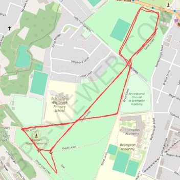
Great Lines Parkrun
- Distance: 3.1 mi
- Elevation gain: 167 ft
- Maximum elevation: 197 ft
- Elevation loss: 177 ft
- Minimum elevation: 125 ft
- Moving time: 29 m 52 s
- Moving speed: 6.3 mph
- Maximum speed: 8.9 mph
- Total time: 29 m 52 s
- Global speed: 6.3 mph
Interactive trail map
Trail profile
- Distance: 3.1 mi
- Elevation gain: 167 ft
- Maximum elevation: 197 ft
- Elevation loss: 177 ft
- Minimum elevation: 125 ft
- Moving time: 29 m 52 s
- Moving speed: 6.3 mph
- Maximum speed: 8.9 mph
- Total time: 29 m 52 s
- Global speed: 6.3 mph
About this trail
Name: Great Lines Parkrun trail, distance, elevation, map, profile, GPS track
Start: Great Lines, Brompton, Gillingham, Medway, England, ME7 5DH, United Kingdom (51.38735 0.53965)
End: Great Lines, Brompton, Gillingham, Medway, England, ME7 5BZ, United Kingdom (51.38857 0.54122)
Coordinates: 51.38181 0.53104 51.38957 0.54130