Thank you for supporting this site ❤️
Make a donation
Make a donation
Gear up for your next adventure:
As an Amazon Associate, this site earns from qualifying purchases at no extra cost to you.
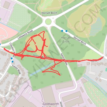
Horsell Birch paths
Woking, horsell, horsell common, horsell birch
- Distance: 2.1 mi
- Elevation gain: 20 ft
- Maximum elevation: 92 ft
- Elevation loss: 20 ft
- Minimum elevation: 79 ft
- Moving time: 45 m 6 s
- Moving speed: 2.9 mph
- Maximum speed: 10.5 mph
- Total time: 46 m 23 s
- Global speed: 2.8 mph
Interactive trail map
Thank you for supporting this site ❤️
Make a donation
Make a donation
Gear up for your next adventure:
As an Amazon Associate, this site earns from qualifying purchases at no extra cost to you.
Trail profile
- Distance: 2.1 mi
- Elevation gain: 20 ft
- Maximum elevation: 92 ft
- Elevation loss: 20 ft
- Minimum elevation: 79 ft
- Moving time: 45 m 6 s
- Moving speed: 2.9 mph
- Maximum speed: 10.5 mph
- Total time: 46 m 23 s
- Global speed: 2.8 mph
Thank you for supporting this site ❤️
Make a donation
Make a donation
Gear up for your next adventure:
As an Amazon Associate, this site earns from qualifying purchases at no extra cost to you.
About this trail
Name: Horsell Birch paths trail, distance, elevation, map, profile, GPS track
Start: Horsell Birch, Horsell, Woking, Surrey, England, GU21 4XB, United Kingdom (51.32663 -0.58195)
End: Horsell Birch, Horsell, Woking, Surrey, England, GU21 4XB, United Kingdom (51.32661 -0.58194)
Coordinates: 51.32568 -0.58994 51.32792 -0.58194
Thank you for supporting this site ❤️
Make a donation
Make a donation
Gear up for your next adventure:
As an Amazon Associate, this site earns from qualifying purchases at no extra cost to you.