Make a donation
Gear up for your next adventure:
As an Amazon Associate, this site earns from qualifying purchases at no extra cost to you.
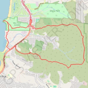
Vallemar Loop
Loop hike around Vallemar via Mori Ridge Trail, Sweeney Ridge Trail, Baquiano Trail, Castle Hill, Farallones View Trail, Rockaway Beach, Bluff Trail, Headlands Trail, The Point and Timigtac Trail in the San Francisco Peninsula Watershed, the Mori Point and the Golden Gate National Recreation Area (GGNRA). #Hiking #Loop #Nature #Mountain #Sea #Pacific #Ocean #Coast #Overlook #Beach #GGNRA
- Distance: 7.5 mi
- Elevation gain: 1,837 ft
- Maximum elevation: 1,230 ft
- Elevation loss: 1,844 ft
- Minimum elevation: 0 ft
- Moving time: 2 h 28 m
- Moving speed: 3.0 mph
- Maximum speed: 4.0 mph
- Total time: 2 h 29 m
- Global speed: 3.0 mph
Interactive trail map
Make a donation
Gear up for your next adventure:
As an Amazon Associate, this site earns from qualifying purchases at no extra cost to you.
Trail profile
- Distance: 7.5 mi
- Elevation gain: 1,837 ft
- Maximum elevation: 1,230 ft
- Elevation loss: 1,844 ft
- Minimum elevation: 0 ft
- Moving time: 2 h 28 m
- Moving speed: 3.0 mph
- Maximum speed: 4.0 mph
- Total time: 2 h 29 m
- Global speed: 3.0 mph
Make a donation
Gear up for your next adventure:
As an Amazon Associate, this site earns from qualifying purchases at no extra cost to you.
About this trail
Name: Vallemar Loop trail, distance, elevation, map, profile, GPS track
Coordinates: 37.60126 -122.49871 37.62062 -122.45782
Topography: San Mateo County topographic map, elevation, terrain
Make a donation
Gear up for your next adventure:
As an Amazon Associate, this site earns from qualifying purchases at no extra cost to you.