Make a donation
Gear up for your next adventure:
As an Amazon Associate, this site earns from qualifying purchases at no extra cost to you.
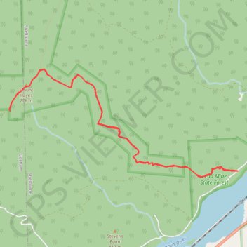
Mount Hayes
Hike from Androscoggin River to Mount Hayes via Centennial Trail and Mahoosuc Trail in the White Mountain National Forest. #Hiking #Mountain #Forest #Nature #River
- Distance: 6.7 mi
- Elevation gain: 2,044 ft
- Maximum elevation: 2,562 ft
- Elevation loss: 2,047 ft
- Minimum elevation: 778 ft
- Moving time: 3 h 10 m
- Moving speed: 2.1 mph
- Maximum speed: 3.2 mph
- Total time: 3 h 50 m
- Global speed: 1.8 mph
Interactive trail map
Make a donation
Gear up for your next adventure:
As an Amazon Associate, this site earns from qualifying purchases at no extra cost to you.
Trail profile
- Distance: 6.7 mi
- Elevation gain: 2,044 ft
- Maximum elevation: 2,562 ft
- Elevation loss: 2,047 ft
- Minimum elevation: 778 ft
- Moving time: 3 h 10 m
- Moving speed: 2.1 mph
- Maximum speed: 3.2 mph
- Total time: 3 h 50 m
- Global speed: 1.8 mph
Make a donation
Gear up for your next adventure:
As an Amazon Associate, this site earns from qualifying purchases at no extra cost to you.
About this trail
Name: Mount Hayes trail, distance, elevation, map, profile, GPS track
Start: Hogan Road, Shelburne, Coös County, New Hampshire, United States (44.40406 -71.12007)
End: Hogan Road, Shelburne, Coös County, New Hampshire, 03581, United States (44.40403 -71.12013)
Coordinates: 44.40315 -71.16341 44.41777 -71.12007
Topography: Coos County topographic map, elevation, terrain
Make a donation
Gear up for your next adventure:
As an Amazon Associate, this site earns from qualifying purchases at no extra cost to you.