Thank you for supporting this site ❤️
Make a donation
Make a donation
Gear up for your next adventure:
As an Amazon Associate, this site earns from qualifying purchases at no extra cost to you.
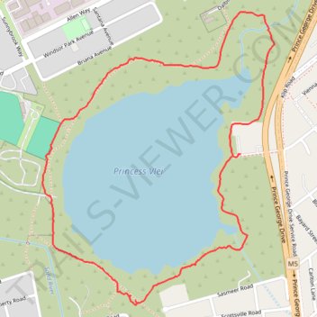
Princess Vlei Loop Trail
- Distance: 1.9 mi
- Elevation gain: 39 ft
- Maximum elevation: 39 ft
- Elevation loss: 43 ft
- Minimum elevation: 23 ft
- Moving time: 1 h 38 s
- Moving speed: 1.9 mph
- Maximum speed: 4.1 mph
- Total time: 1 h 26 m
- Global speed: 1.3 mph
Interactive trail map
Thank you for supporting this site ❤️
Make a donation
Make a donation
Gear up for your next adventure:
As an Amazon Associate, this site earns from qualifying purchases at no extra cost to you.
Trail profile
- Distance: 1.9 mi
- Elevation gain: 39 ft
- Maximum elevation: 39 ft
- Elevation loss: 43 ft
- Minimum elevation: 23 ft
- Moving time: 1 h 38 s
- Moving speed: 1.9 mph
- Maximum speed: 4.1 mph
- Total time: 1 h 26 m
- Global speed: 1.3 mph
Thank you for supporting this site ❤️
Make a donation
Make a donation
Gear up for your next adventure:
As an Amazon Associate, this site earns from qualifying purchases at no extra cost to you.
About this trail
Name: Princess Vlei Loop Trail trail, distance, elevation, map, profile, GPS track
Coordinates: -34.05213 18.47894 -34.04358 18.48709
Thank you for supporting this site ❤️
Make a donation
Make a donation
Gear up for your next adventure:
As an Amazon Associate, this site earns from qualifying purchases at no extra cost to you.