Thank you for supporting this site ❤️
Make a donation
Make a donation
Gear up for your next adventure:
As an Amazon Associate, this site earns from qualifying purchases at no extra cost to you.
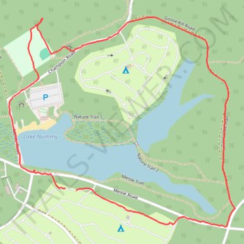
Lake Nummy Loop - Belleplain State Forest
- Distance: 1.9 mi
- Elevation gain: 23 ft
- Maximum elevation: 43 ft
- Elevation loss: 23 ft
- Minimum elevation: 26 ft
- Moving time: 52 m 7 s
- Moving speed: 2.2 mph
- Maximum speed: 4.6 mph
- Total time: 55 m 6 s
- Global speed: 2.0 mph
Interactive trail map
Thank you for supporting this site ❤️
Make a donation
Make a donation
Gear up for your next adventure:
As an Amazon Associate, this site earns from qualifying purchases at no extra cost to you.
Trail profile
- Distance: 1.9 mi
- Elevation gain: 23 ft
- Maximum elevation: 43 ft
- Elevation loss: 23 ft
- Minimum elevation: 26 ft
- Moving time: 52 m 7 s
- Moving speed: 2.2 mph
- Maximum speed: 4.6 mph
- Total time: 55 m 6 s
- Global speed: 2.0 mph
Thank you for supporting this site ❤️
Make a donation
Make a donation
Gear up for your next adventure:
As an Amazon Associate, this site earns from qualifying purchases at no extra cost to you.
About this trail
Name: Lake Nummy Loop - Belleplain State Forest trail, distance, elevation, map, profile, GPS track
Coordinates: 39.24355 -74.85878 39.25053 -74.84908
Topography: Dennis Township topographic map, elevation, terrain
Thank you for supporting this site ❤️
Make a donation
Make a donation
Gear up for your next adventure:
As an Amazon Associate, this site earns from qualifying purchases at no extra cost to you.