Make a donation
Gear up for your next adventure:
As an Amazon Associate, this site earns from qualifying purchases at no extra cost to you.
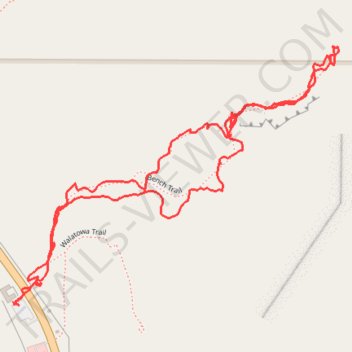
Walatowa Bench Trail, Red Rocks Trail and Slot Canyon hike
- Distance: 1.9 mi
- Elevation gain: 322 ft
- Maximum elevation: 5,869 ft
- Elevation loss: 322 ft
- Minimum elevation: 5,620 ft
- Moving time: 1 h 9 m
- Moving speed: 1.7 mph
- Maximum speed: 5.1 mph
- Total time: 1 h 30 m
- Global speed: 1.3 mph
Interactive trail map
Make a donation
Gear up for your next adventure:
As an Amazon Associate, this site earns from qualifying purchases at no extra cost to you.
Trail profile
- Distance: 1.9 mi
- Elevation gain: 322 ft
- Maximum elevation: 5,869 ft
- Elevation loss: 322 ft
- Minimum elevation: 5,620 ft
- Moving time: 1 h 9 m
- Moving speed: 1.7 mph
- Maximum speed: 5.1 mph
- Total time: 1 h 30 m
- Global speed: 1.3 mph
Make a donation
Gear up for your next adventure:
As an Amazon Associate, this site earns from qualifying purchases at no extra cost to you.
About this trail
Name: Walatowa Bench Trail, Red Rocks Trail and Slot Canyon hike trail, distance, elevation, map, profile, GPS track
Start: NM 4, Sandoval County, New Mexico, 87024, United States (35.64488 -106.72597)
End: NM 4, Sandoval County, New Mexico, 87024, United States (35.64486 -106.72604)
Coordinates: 35.64485 -106.72607 35.65040 -106.71750
Topography: Sandoval County topographic map, elevation, terrain
Make a donation
Gear up for your next adventure:
As an Amazon Associate, this site earns from qualifying purchases at no extra cost to you.