Thank you for supporting this site ❤️
Make a donation
Make a donation
Gear up for your next adventure:
As an Amazon Associate, this site earns from qualifying purchases at no extra cost to you.
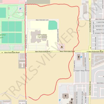
New James Brown walking path Eastside
- Distance: 2.2 mi
- Elevation gain: 82 ft
- Maximum elevation: 2,674 ft
- Elevation loss: 79 ft
- Minimum elevation: 2,598 ft
- Moving time: 42 m 37 s
- Moving speed: 3.1 mph
- Maximum speed: 5.9 mph
- Total time: 43 m 41 s
- Global speed: 3.1 mph
Interactive trail map
Thank you for supporting this site ❤️
Make a donation
Make a donation
Gear up for your next adventure:
As an Amazon Associate, this site earns from qualifying purchases at no extra cost to you.
Trail profile
- Distance: 2.2 mi
- Elevation gain: 82 ft
- Maximum elevation: 2,674 ft
- Elevation loss: 79 ft
- Minimum elevation: 2,598 ft
- Moving time: 42 m 37 s
- Moving speed: 3.1 mph
- Maximum speed: 5.9 mph
- Total time: 43 m 41 s
- Global speed: 3.1 mph
Thank you for supporting this site ❤️
Make a donation
Make a donation
Gear up for your next adventure:
As an Amazon Associate, this site earns from qualifying purchases at no extra cost to you.
About this trail
Name: New James Brown walking path Eastside trail, distance, elevation, map, profile, GPS track
Start: South Cimarron Road, Clark County, Nevada, 89113, United States (36.04310 -115.26979)
End: South Cimarron Road, Clark County, Nevada, 89113, United States (36.04281 -115.27014)
Coordinates: 36.04273 -115.27031 36.05374 -115.26264
Topography: Clark County topographic map, elevation, terrain
Thank you for supporting this site ❤️
Make a donation
Make a donation
Gear up for your next adventure:
As an Amazon Associate, this site earns from qualifying purchases at no extra cost to you.