Thank you for supporting this site ❤️
Make a donation
Make a donation
Gear up for your next adventure:
As an Amazon Associate, this site earns from qualifying purchases at no extra cost to you.
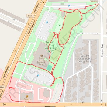
Canyon Country Community Center
- Distance: 0.9 mi
- Elevation gain: 36 ft
- Maximum elevation: 1,473 ft
- Elevation loss: 36 ft
- Minimum elevation: 1,440 ft
- Moving time: 21 m 59 s
- Moving speed: 2.5 mph
- Maximum speed: 4.2 mph
- Total time: 24 m 20 s
- Global speed: 2.2 mph
Interactive trail map
Thank you for supporting this site ❤️
Make a donation
Make a donation
Gear up for your next adventure:
As an Amazon Associate, this site earns from qualifying purchases at no extra cost to you.
Trail profile
- Distance: 0.9 mi
- Elevation gain: 36 ft
- Maximum elevation: 1,473 ft
- Elevation loss: 36 ft
- Minimum elevation: 1,440 ft
- Moving time: 21 m 59 s
- Moving speed: 2.5 mph
- Maximum speed: 4.2 mph
- Total time: 24 m 20 s
- Global speed: 2.2 mph
Thank you for supporting this site ❤️
Make a donation
Make a donation
Gear up for your next adventure:
As an Amazon Associate, this site earns from qualifying purchases at no extra cost to you.
About this trail
Name: Canyon Country Community Center trail, distance, elevation, map, profile, GPS track
Coordinates: 34.41657 -118.45539 34.41918 -118.45253
Topography: Santa Clarita topographic map, elevation, terrain
Thank you for supporting this site ❤️
Make a donation
Make a donation
Gear up for your next adventure:
As an Amazon Associate, this site earns from qualifying purchases at no extra cost to you.